| |
|
|
|
|
|
|
|
SPN-43 Shipborne Radar
|
The AN/SPN-43C is a U.S. Navy air traffic control (ATC) radar for large-deck amphibious ships that are capable of supporting flight operations. These vessels include aircraft carriers (CVN) and amphibious assault ships (LHA and LHD) that predominantly carry helicopters.
U.S. homeports for ships that carry the SPN-43 are Norfolk VA, San Diego CA, Bremerton WA, and Newport News VA. The SPN-43 is currently installed on 21 commissioned ships in the U.S. Navy. It may also be installed on some non-U.S. military ships.
Land-based testing and training sites for the SPN-43 are at St. Inigoes (Pax River) MD, Pascagoula MS, and Pensacola FL, per footnote US348.
The SPN-43 possesses the following technical characteristics:
-Modulation P0N (unmodulated pulses, no information transmitted)
-Tuning range 3500-3700 MHz
-Peak tx power into antenna: 1 MW (60 dBW)
-Antenna gain: 32 dBi
-Peak EIRP: 1.6 GW (92 dBW)
-Pulse width: 0.95 microseconds
-Pulse repetition rate: 1 kHz
-Duty cycle: 0.1%
-Transmit bandwidth: 1.6 MHz
-Antenna type: Rotating parabolic
-Beamwidth: 1.75 deg horizontal, 4.4 deg vertical (vertical fan beam, csc2 to 30 deg elevation)
-Polarization: Horizontal
-Antenna rotation rate: One revolution per 4 seconds
In the range 3650-3700 MHz, operation of the radar is only allowed more than 50 miles off shore.
|
Frequency Bands |
| Band | Use | Service | Table |
| 3500 - 3700 MHz | SPN-43 shipborne air traffic control radar | Radiolocation | F |
Display this entry in a page by itself
Edit
|
|
|
|
|
|
SPY-1 Shipborne Air Surveillance Radar
|
The SPY-1 is a U.S. Navy phased array surveillance radar that is a component of the Aegis combat system. It is installed on guided missile cruisers (CG) and guided missile destroyers (DDG). Several variants of the SPY-1, including the -1A, -1B(V), -1D, and -1F are in service, modified to fit specific types of vessels. The -1F is not installed on any U.S. ships.
U.S. land-based test and training sites for the SPY-1 are at Moorestown, NJ, and Wallops Island, VA.
The SPY-1 possesses the following technical characteristics according to ITU-R Recommendation M.1465:
-Modulation: Q7N (angle-modulated, two or more digital channels, no information transmitted)
-Tuning range: 3100-3500 MHz
-Peak tx power into antenna: 4 – 6.4 MW (66 – 68 dBW)
-Antenna gain: 42 dBi
-Peak EIRP: 63 – 101 GW (108-110 dBW)
-Pulse width: 6.4 – 51.2 microseconds
-Pulse repetition rate: 0.152-6 kHz
-Duty cycle: 0.8-2.0%
-Tx bandwidth (-3 dB): 4 MHz
-Average EIRP (=peak EIRP x duty cycle): 504 MW – 2 GW (87-93 dBW)
-Minimum effective isotropic power spectral density: 126 W/Hz (51 dBm/Hz)
-Maximum effective power isotropic spectral density: 500 W/Hz (57 dBm/Hz)
-Antenna type: Phased array
-Beamwidth: 1.7 deg (azimuth and elevation)
-Polarization: Vertical
-Antenna rotation rate: N/A (electronically steered)
The SPY-1 is known to emit very high levels of out-of-band emissions outside of the 3100-3500 MHz band.
|
Frequency Bands |
| Band | Use | Service | Table |
| 3100 - 3500 MHz | SPY-1 Shipborne Air Surveillance Radar | Radiolocation | F |
Associated Files:

SPY-1 phased array antenna panels on the guided missile destroyer USS Laboon, photographed in the Chesapeake Bay near Norfolk, Virginia.
Display this entry in a page by itself
Edit
|
|
|
|
|
|
|
|
UK Broadband
|
According to a UK Broadband press release (c. 2012):
UK Broadband, the UK’s largest holder of 4G spectrum, has today announced that it has switched on its first 4G LTE system in London. This is the first TD-LTE 3.5GHz deployment in the world and the first commercial 4G deployment in the UK. UK Broadband (UKB) is building its network using Huawei’s Time Division Long Term Evolution (TD-LTE) solution.
UKB will operate a wholesale model, working with partners to offer commercial services from May 2012 to businesses, consumers and the public sector. The network will initially cover the Southbank and Borough areas of Southwark.
The network will use UKB’s 124MHz of spectrum in LTE bands 42 and 43 (3.5GHz and 3.6GHz). This allows the deployment of 6 x 20MHz wide channels that will enable UKB to deliver LTE Advanced speeds and enough capacity across the network to deliver Next Generation Access superfast broadband speeds to a large number of users simultaneously.
The first devices, jointly developed by UKB and Huawei, include indoor and outdoor units for high-speed wireless broadband to homes and businesses within the coverage area. Multi-mode mobile devices supporting TD-LTE, FD-LTE and 3G will be available from September 2012.
“We’re very excited to be switching on our first TD-LTE system in the UK using our 4G spectrum,” said Nicholas James, UKB’s CEO. “We’re working with Huawei because we believe they have the expertise and experience we need to deliver the best solution.”
"Utilising Huawei’s equipment, UKB’s spectrum and our combined expertise, the availability of LTE in the UK from today will give a significant boost to the UK’s Government’s broadband agenda,” said Victor Zhang, CEO of Huawei UK. “We are proud to be involved in this project and are dedicated to supporting UKB and the Government to help connect more people to high speed wireless broadband networks.’’
UKB’s business model is to build bespoke LTE coverage – large or small – that delivers solutions to where there is demand for high speed wireless/mobile data capacity. Usually this will be as a result of developing a solution for an anchor or core customer.
UKB has chosen TD LTE because typically, significantly more data is downloaded than uploaded. Designed specifically to meeting the growing demand for data capacity, TD LTE allows UKB to dynamically manage the network to maximise the download capacity at all times, optimising both the technology and the wide spectrum bands it has available to deliver a very high download capacity.
|
Frequency Bands |
| Band | Use | Service | Table |
| 3480 - 3500 MHz | UK Broadband TD-LTE | Mobile | - |
| 3580 - 3600 MHz | UK Broadband TD-LTE | Mobile | - |
| 3605 - 3689 MHz | UK Broadband TD-LTE | Mobile | - |
| 3925 - 4009 MHz | UK Broadband TD-LTE | Mobile | - |
External Links:
Display this entry in a page by itself
Edit
|
|
|
|
|
|
|
|
|
|
|
|
IEEE 802.15.4 HRP UWB
|
High pulse repetition frequency ultra-wideband (HPR UWB) is one of the physical layers defined for low data rate personal area network (LR-WPAN) communications in the IEEE 802.15.4 standard.
According to the FiRa Consortium:
"In challenging environments, such as parking structures, hospitals, airports and high density venues, ultra-wideband (UWB) technology outperforms other technologies in terms of accuracy, power consumption, robustness in wireless connectivity, and security, by a wide margin.
"UWB securely determines the relative position of peer devices with a very high degree of accuracy and can operate with line of sight at up to 200 meters. In contrast to narrow band wireless technologies, the use of wide bandwidth means UWB provides very stable connectivity, with little to no interference and offers highly precise positioning, even in congested multi-path signal environments.
"By calculating precise location, fine ranging based on UWB is a more secure approach to closing and opening locks, whether those locks are installed on a car door, a warehouse entryway, a conference room, or your front door."
|
Frequencies |
| Frequency | Bandwidth | Use | Service | Table |
| 499.2 MHz | 499.2 MHz | 802.15.4 HRP UWB Channel 0 | - | - |
| 3494.4 MHz | 499.2 MHz | 802.15.4 HRP UWB Channel 1 | - | - |
| 3993.6 MHz | 499.2 MHz | 802.15.4 HRP UWB Channel 2 | - | - |
| 3993.6 MHz | 1.3312 GHz | 802.15.4 HRP UWB Channel 4 | - | - |
| 4492.8 MHz | 499.2 MHz | 802.15.4 HRP UWB Channel 3 | - | - |
| 6489.6 MHz | 1.0816 GHz | 802.15.4 HRP UWB Channel 7 | - | - |
| 6489.6 MHz | 499.2 MHz | 802.15.4 HRP UWB Channel 5 | - | - |
| 6988.8 MHz | 499.2 MHz | 802.15.4 HRP UWB Channel 6 | - | - |
| 7488 MHz | 499.2 MHz | 802.15.4 HRP UWB Channel 8 | - | - |
| 7987.2 MHz | 1.3312 GHz | 802.15.4 HRP UWB Channel 11 | - | - |
| 7987.2 MHz | 499.2 MHz | 802.15.4 HRP UWB Channel 9 | - | - |
| 8486.4 MHz | 499.2 MHz | 802.15.4 HRP UWB Channel 10 | - | - |
| 8985.6 MHz | 499.2 MHz | 802.15.4 HRP UWB Channel 12 | - | - |
| 9484.8 MHz | 1.35497 GHz | 802.15.4 HRP UWB Channel 15 | - | - |
| 9484.8 MHz | 499.2 MHz | 802.15.4 HRP UWB Channel 13 | - | - |
| 9984 MHz | 499.2 MHz | 802.15.4 HRP UWB Channel 14 | - | - |
External Links:
Associated Files:
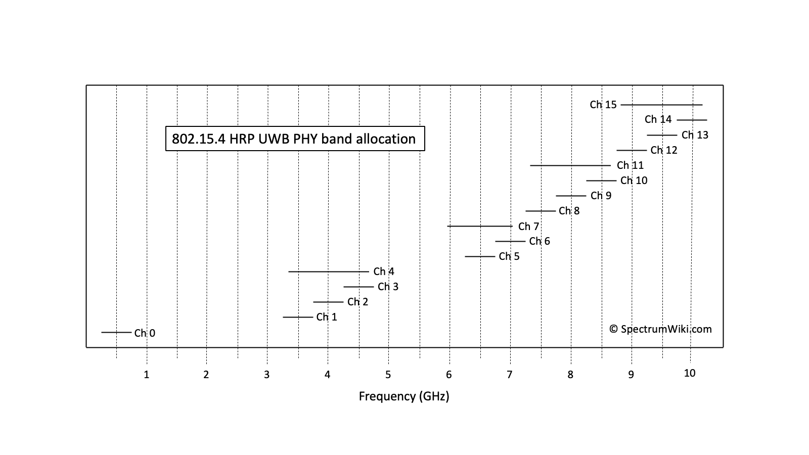
802.15.4 HRP UWB PHY band allocation
Display this entry in a page by itself
Edit
|
|
|
|
|
|
|