Allocations

 
U.S. Non-Federal-Government Allocations
3300 - 3450 MHz


U.S. Federal Government Allocations
3300 - 3500 MHz
RADIOLOCATION US431B G2


ITU Region 1 Allocations
3300 - 3400 MHz
RADIOLOCATION


ITU Region 2 Allocations
3300 - 3400 MHz
RADIOLOCATION
Amateur
Fixed
Mobile


ITU Region 3 Allocations
3300 - 3400 MHz
RADIOLOCATION
Amateur


SpectrumWiki

Band Uses (3.3 - 3.5 GHz)


Footnotes

5.149   In making assignments to stations of other services to which the bands:
13 360-13 410 kHz,
25 550-25 670 kHz,
37.5-38.25 MHz,
73-74.6 MHz in Regions 1 and 3,
150.05-153 MHz in Region 1,
322-328.6 MHz,
406.1-410 MHz,
608-614 MHz in Regions 1 and 3,
1 330-1 400 MHz,
1 610.6-1 613.8 MHz,
1 660-1 670 MHz,
1 718.8-1 722.2 MHz,
2 655-2 690 MHz,
3 260-3 267 MHz,
3 332-3 339 MHz,
3 345.8-3 352.5 MHz,
4 825-4 835 MHz, 4 950-4 990 MHz,
4 990-5 000 MHz,
6 650-6 675.2 MHz,
10.6-10.68 GHz,
14.47-14.5 GHz,
22.01-22.21 GHz,
22.21-22.5 GHz,
22.81-22.86 GHz,
23.07-23.12 GHz,
31.2-31.3 GHz,
31.5-31.8 GHz in Regions 1 and 3,
36.43-36.5 GHz,
42.5-43.5 GHz,
48.94-49.04 GHz,
76-86 GHz,
92-94 GHz,
94.1-100 GHz, 102-109.5 GHz,
111.8-114.25 GHz,
128.33-128.59 GHz,
129.23-129.49 GHz,
130-134 GHz,
136-148.5 GHz,
151.5-158.5 GHz,
168.59-168.93 GHz,
171.11-171.45 GHz,
172.31-172.65 GHz,
173.52-173.85 GHz,
195.75-196.15 GHz,
209-226 GHz,
241-250 GHz,
252-275 GHz
are allocated, administrations are urged to take all practicable steps to protect the radio astronomy service from harmful interference. Emissions from spaceborne or airborne stations can be particularly serious sources of interference to the radio astronomy service (see Nos. 4.5 and 4.6 and Article 29). (WRC 07)

5.429   Additional allocation: in Saudi Arabia, Bahrain, Bangladesh, Benin, Brunei Darussalam, Cambodia, Cameroon, China, Congo (Rep. of the), Korea (Rep. of), Côte d'Ivoire, Egypt, the United Arab Emirates, India, Indonesia, Iran (Islamic Republic of), Iraq, Japan, Jordan, Kenya, Kuwait, Lebanon, Libya, Malaysia, New Zealand, Oman, Uganda, Pakistan, Qatar, the Syrian Arab Republic, the Dem. Rep. of the Congo, the Dem. People’s Rep. of Korea, Sudan and Yemen, the frequency band 3 300-3 400 MHz is also allocated to the fixed and mobile services on a primary basis. New Zealand and the countries bordering the Mediterranean shall not claim protection for their fixed and mobile services from the radiolocation service. (WRC 19)

5.429A   Additional allocation: in Angola, Benin, Botswana, Burkina Faso, Burundi, Djibouti, Eswatini, Ghana, Guinea, Guinea-Bissau, Lesotho, Liberia, Malawi, Mauritania, Mozambique, Namibia, Niger, Nigeria, Rwanda, Sudan, South Sudan, South Africa, Tanzania, Chad, Togo, Zambia and Zimbabwe, the frequency band 3 300 3 400 MHz is allocated to the mobile, except aeronautical mobile, service on a primary basis. Stations in the mobile service operating in the frequency band 3 300-3 400 MHz shall not cause harmful interference to, or claim protection from, stations operating in the radiolocation service. (WRC 19)

5.429B   In the following countries of Region 1 south of 30° parallel north: Angola, Benin, Botswana, Burkina Faso, Burundi, Cameroon, Congo (Rep. of the), Côte d’Ivoire, Egypt, Eswatini, Ghana, Guinea, Guinea-Bissau, Kenya, Lesotho, Liberia, Malawi, Mauritania, Mozambique, Namibia, Niger, Nigeria, Uganda, the Dem. Rep. of the Congo, Rwanda, Sudan, South Sudan, South Africa, Tanzania, Chad, Togo, Zambia and Zimbabwe, the frequency band 3 300-3 400 MHz is identified for the implementation of International Mobile Telecommunications (IMT). The use of this frequency band shall be in accordance with Resolution 223 (Rev.WRC 19). The use of the frequency band 3 300-3 400 MHz by IMT stations in the mobile service shall not cause harmful interference to, or claim protection from, systems in the radiolocation service, and administrations wishing to implement IMT shall obtain the agreement of neighbouring countries to protect operations within the radiolocation service. This identification does not preclude the use of this frequency band by any application of the services to which it is allocated and does not establish priority in the Radio Regulations. (WRC 19)

5.429C   Different category of service: in Argentina, Belize, Brazil, Chile, Colombia, Costa Rica, the Dominican Republic, El Salvador, Ecuador, Guatemala, Mexico, Paraguay and Uruguay, the frequency band 3 300-3 400 MHz is allocated to the mobile, except aeronautical mobile, service on a primary basis. In Argentina, Brazil, the Dominican Republic, Guatemala, Mexico, Paraguay and Uruguay, the frequency band 3 300-3 400 MHz is also allocated to the fixed service on a primary basis. Stations in the fixed and mobile services operating in the frequency band 3 300-3 400 MHz shall not cause harmful interference to, or claim protection from, stations operating in the radiolocation service. (WRC 19)

5.429D   In the following countries in Region 2: Argentina, Belize, Brazil, Chile, Colombia, Costa Rica, the Dominican Republic, El Salvador, Ecuador, Guatemala, Mexico, Paraguay and Uruguay, the use of the frequency band 3 300-3 400 MHz is identified for the implementation of International Mobile Telecommunications (IMT). Such use shall be in accordance with Resolution 223 (Rev.WRC 19). This use in Argentina, Paraguay and Uruguay is subject to the application of No. 9.21. The use of the frequency band 3 300-3 400 MHz by IMT stations in the mobile service shall not cause harmful interference to, or claim protection from, systems in the radiolocation service, and administrations wishing to implement IMT shall obtain the agreement of neighbouring countries to protect operations within the radiolocation service. This identification does not preclude the use of this frequency band by any application of the services to which it is allocated and does not establish priority in the Radio Regulations. (WRC 19)

5.429E   Additional allocation: in Papua New Guinea, the frequency band 3 300-3 400 MHz is allocated to the mobile, except aeronautical mobile, service on a primary basis. Stations in the mobile service operating in the frequency band 3 300-3 400 MHz shall not cause harmful interference to, or claim protection from, stations operating in the radiolocation service. (WRC 15)

5.429F   In the following countries in Region 3: Cambodia, India, Indonesia, Lao P.D.R., Pakistan, the Philippines and Viet Nam, the use of the frequency band 3 300-3 400 MHz is identified for the implementation of International Mobile Telecommunications (IMT). Such use shall be in accordance with Resolution 223 (Rev.WRC 19). The use of the frequency band 3 300-3 400 MHz by IMT stations in the mobile service shall not cause harmful interference to, or claim protection from, systems in the radiolocation service. Before an administration brings into use a base or mobile station of an IMT system in this frequency band, it shall seek agreement under No. 9.21 with neighbouring countries to protect the radiolocation service. This identification does not preclude the use of this frequency band by any application of the services to which it is allocated and does not establish priority in the Radio Regulations. (WRC 19)

5.430   Additional allocation: in Kyrgyzstan and Turkmenistan, the frequency band 3 300-3 400 MHz is also allocated to the radionavigation service on a primary basis. (WRC 19)

US103   In the band 3300-3550 MHz, non-Federal stations in the radiolocation service that were licensed (or licensed pursuant to applications accepted for filing) before February 22, 2019 may continue to operate on a secondary basis until 180 days after the issuance of the first flexible-use licenses in the 3.45 GHz Service. No new assignments shall be made. In the band 3300-3500 MHz, stations in the amateur service may continue to operate on a secondary basis until new flexible-use licenses are issued for operation in the band in which they operate. Amateur operations between 3450 MHz and 3500 MHz must cease within 90 days of the public notice announcing the close of the auction for the 3.45 GHz Service. Stations in the amateur service may continue to operate in the band 3300-3450 MHz on a secondary basis while the band’s future uses are finalized, but stations in the amateur service may be required to cease operations in the band 3300-3450 MHz at any time if the amateur service causes harmful interference to flexible-use operations.

US342   In making assignments to stations of other services to which the bands:

13 360-13 410 kHz42.77-42.87 GHz*
25 550-25 670 kHz43.07-43.17 GHz*
37.5-38.25 MHz43.37-43.47 GHz*
322-328.6 MHz*48.94-49.04 GHz*
1330-1400 MHz*76-86 GHz
1610.6-1613.8 MHz*92-94 GHz
1660-1660.5 MHz*94.1-100 GHz
1668.4-1670 MHz*102-109.5 GHz
3260-3267 MHz*111.8-114.25 GHz
3332-3339 MHz*128.33-128.59 GHz*
3345.8-3352.5 MHz*129.23-129.49 GHz*
4825-4835 MHz*130-134 GHz
4950-4990 MHz136-148.5 GHz
6650-6675.2 MHz*151.5-158.5 GHz
14.47-14.5 GHz*168.59-168.93 GHz*
22.01-22.21 GHz*171.11-171.45 GHz*
22.21-22.5 GHz172.31-172.65 GHz*
22.81-22.86 GHz*173.52-173.85 GHz*
23.07-23.12 GHz*195.75-196.15 GHz*
31.2-31.3 GHz209-226 GHz
36.43-36.5 GHz*241-250 GHz
42.5-43.5 GHz252-275 GHz

are allocated (*indicates radio astronomy use for spectral line observations), all practicable steps shall be taken to protect the radio astronomy service from harmful interference. Emissions from spaceborne or airborne stations can be particularly serious sources of interference to the radio astronomy service (see ITU Radio Regulations at Nos. 4.5 and 4.6 and Article 29).

G2   In the bands 216.965-216.995 MHz, 420-450 MHz (except as provided for in G129), 890-902 MHz, 928-942 MHz, 1300-1390 MHz, 2310-2390 MHz, 2417-2450 MHz, 2700-2900 MHz, 3300-3500 MHz, 5650-5925 MHz, and 9000-9200 MHz, use of the Federal radiolocation service is restricted to the military services.

US431B   The band 3450-3550 MHz is allocated on a primary basis to the Federal radiolocation service and to the non-Federal fixed and mobile, except aeronautical mobile, services on a nationwide basis. Federal operations in the band 3450-3550 MHz shall not cause harmful interference to non-Federal operations, except under the following circumstances.

    (a) Cooperative Planning Areas. Cooperative Planning Areas (CPAs) are geographic locations in which non-Federal operations shall coordinate with Federal systems in the band to deploy non-Federal operations in a manner that shall not cause harmful interference to Federal systems operating in the band. In addition, operators of non-Federal stations may be required to modify their operations (e.g., reduce power, filtering, adjust antenna pointing angles, shielding, etc.) to protect Federal operations against harmful interference and to avoid, where possible, interference and potential damage to the non-Federal operators’ systems. In these areas, non-Federal operations may not claim interference protection from Federal systems. Federal and non-Federal operators may reach mutually acceptable operator-to-operator agreements to permit more extensive non-Federal use by identifying and mutually agreeing upon a technical approach that mitigates the interference risk to Federal operations. To the extent possible, Federal use in CPAs will be chosen to minimize operational impact on non-Federal users. The table in paragraph (d) identifies the locations of CPAs, including, for information, those with high powered Federal operations. CPAs may also be Periodic Use Areas as described below. Coordination between Federal users and non-Federal licensees in CPAs shall be consistent with rules and procedures established by the FCC and NTIA.

    (b) Periodic Use Areas. Periodic Use Areas (PUAs) are geographic locations in which non-Federal operations in the band shall not cause harmful interference to Federal systems operating in the band for episodic periods. During these times and in these areas, Federal users will require interference protection from non-Federal operations. Operators of non-Federal stations may be required to temporarily modify their operations (e.g., reduce power, filtering, adjust antenna pointing angles, shielding, etc.) to protect Federal operations from harmful interference, which may include restrictions on non-Federal stations’ ability to radiate at certain locations during specific periods of time. During such episodic use, non-Federal users in PUAs must alter their operations to avoid harmful interference to Federal systems’ temporary use of the band, and during such times, non-Federal operations may not claim interference protection from Federal systems. Federal and non-Federal operators may reach mutually acceptable operator-to-operator agreements such that a Federal operator may not need to activate a PUA if a mutually agreeable technical approach mitigates the interference risk to Federal operations. To the extent possible, Federal use in PUAs will be chosen to minimize operational impact on non-Federal users. Coordination between Federal users and non-Federal licensees in PUAs shall be consistent with rules and procedures established by the FCC and NTIA. While all PUAs are co-located with CPAs, the exact geographic area used during periodic use may differ from the co-located CPA. The geographic locations of PUAs are identified in the table in paragraph (d). Restrictions and authorizations for the CPAs remain in effect during periodic use unless specifically relieved in the coordination process.

    (c) For the CPA at Little Rock, AR, after approximately 12 months from the close of the auction, non-Federal operations shall coordinate with Federal systems in only the 3450-3490 MHz band segment and the 3490-3550 MHz band segment will be available for non-federal use without coordination. At Fort Bragg, NC, non-Federal operations shall coordinate with Federal systems in only the 3450-3490 MHz band segment.

    (d) The following table identifies the coordinates for the location of each CPA and PUA. An area may be represented as either a polygon made up of several corresponding coordinates or a circle represented by a center point and a radius. If a CPA has a corresponding PUA, the PUA coordinates are provided. A location marked with an asterisk (*) indicates a high-power federal radiolocation facility. If a location includes a Shipboard Electronic Systems Evaluation Facility (SESEF) attached to a homeport, it specifies the associated SESEF.

Table: Department of Defense Cooperative Planning Areas and Period Use Areas
Location nameStateCPAPUA LatitudeLongitudeRadius (km)
Little Rock AR Yes - 37° 28’ 34”
37° 42’ 55”
36° 38’ 29”
34° 57’ 57”
32° 09’ 36”
31° 51’ 52”
32° 12’ 11”
33° 42’ 22”
35° 17’ 35”
36° 12’ 18”
94° 28’ 24”
88° 54’ 36”
87° 52’ 34”
88° 09’ 26”
92° 06’ 54”
93° 10’ 35”
94° 37’ 07”
95° 49’ 52”
96° 23’ 06”
96° 08’ 46”
N/A
Yuma Complex (includes Yuma Proving Grounds and MCAS Yuma) AZ Yes Yes 33° 36' 44''
34° 03' 08''
34° 03' 56''
33° 26' 54''
32° 51' 17''
32° 16' 54''
32° 14' 39''
32° 20' 06''
32° 28' 30''
32° 53' 20''
115° 10' 44''
114° 41' 08''
114° 05' 56''
113° 03' 54''
113° 02' 17''
113° 45' 54''
114° 40' 39''
114° 55' 06''
115° 02' 30''
115° 09' 20''
N/A
Camp Pendleton CA Yes - 33° 21’ 46” 117° 25’25” 50
Edwards Air Force Base CA Yes Yes 35º 19’ 16”
35º 17’ 54”
35º 11’ 43”
35º 00’ 52”
34º 44’ 17”
34º 34’ 16”
34º 26’ 55”
34º 28’ 59”
34º 41’ 36”
35º 07’ 32”
118º 03’ 16”
117º 26’ 54”
117º 15’ 43”
117º 10’ 52”
117º 10’ 17”
117º 19’ 16”
117º 47’ 55”
118º 16’ 59”
118º 28’ 36”
118º 25’ 32”
N/A
National Training Center CA Yes Yes 36° 03' 31''
36° 03' 09''
35° 41' 46''
35° 07' 24''
34° 42' 43''
34° 44' 22''
35° 02' 28''
35° 34' 49''
117° 00' 45''
116° 20' 43''
115° 44' 31''
115° 44' 09''
116° 17' 58''
117° 05' 19''
117° 35' 18''
117° 27' 37''
N/A
Naval Air Weapons Station, China Lake* CA Yes Yes 36º 36’ 42”
35º 54’ 45”
35º 00’ 01”
34º 54’ 34”
35º 44’ 22”
36º 30’ 18
117º 20’ 42”
116º 31’ 45”
116º 39’ 01”
117º 26’ 34”
118º 17’ 22”
118º 07’ 18”
N/A
Point Mugu CA Yes Yes 34° 06’ 44” 119° 06’ 36” 38
San Diego* (includes Point Loma SESEF range) CA Yes - 33° 04' 10''
32° 27' 19''
32° 33' 29''
32° 47' 16''
33° 01' 20''
33° 20' 36''
33° 24' 36''
32° 52' 54''
33° 04' 10''
117° 35' 40''
118° 00' 37''
116° 51' 8''
116° 28' 5''
116° 31' 5''
116° 47' 10''
117° 00' 51''
117° 09' 35''
117° 35' 40''
N/A
Twentynine Palms CA Yes - 34° 06’ 44” 116° 06' 36'' 75
Eglin Air Force Base (includes Santa Rosa Island & Cape San Blas site) FL Yes Yes Eglin and Santa Rosa Island: 30º 29’ 28.5” Cape San Blas: 29º 40’ 37” Eglin and Santa Rosa Island: 86º 45’ 00” Cape San Blas: 85º 20’ 50” 35
Mayport* (includes Mayport SESEF range) FL Yes - 30° 23’ 42” 81° 24’ 41” 64
Pensacola* FL Yes Yes 30° 20' 50 87° 18' 40'' 93
Joint Readiness Training Center LA Yes Yes 31° 54' 23''
31° 50' 54''
31° 18' 13''
30° 46' 33''
30° 29' 14''
30° 46' 22''
31° 25' 16''
93° 20' 53''
92° 52' 46''
92° 26' 31''
92° 28' 32''
93° 04' 01''
93° 41' 26''
94° 03' 19''
N/A
Chesapeake Beach* MD Yes Yes 38° 39' 24'' 76° 31' 41'' 95
Naval Air Station, Patuxent River

CPA

MD Yes Yes 38° 26' 22''
38° 51' 51''
38° 28' 11''
38° 03' 40''
37° 45' 33''
37° 34' 34''
37° 38' 10''
38° 09' 32''
38° 18' 46''
38° 26' 59''
76° 14' 12''
75° 48' 34''
75° 28' 53''
75° 30' 31''
75° 45' 50''
76° 20' 09''
76° 44' 37''
76° 29' 28''
76° 34' 36''
76° 26' 27''
N/A
Naval Air Station, Patuxent River

PUA

MD Yes Yes 38° 33’ 38”
39° 11’ 10”
38° 38’ 51”
37° 52’ 13”
37° 29’ 44”
37° 10’ 24”
37° 20’ 05”
38° 01’ 11”
38° 20’ 54”
38° 35’ 47”
76° 07’ 29”
75° 29’ 28”
75° 00’ 40”
75° 03’ 24”
75° 22’ 25”
76° 16’ 42”
77° 06’ 52”
76° 36’ 06”
76° 46’ 41”
76° 30’ 02”
N/A
St. Inigoes* MD Yes Yes 38° 08' 41'' 76° 26' 03'' 87
Bath* ME Yes Yes 44° 02' 29''
43° 52' 27''
43° 48' 53''
43° 32' 50''
43° 27' 16''
43° 44' 26''
43° 54' 57''
44° 06' 56''
44° 17' 02''
44° 26' 54''
44° 36' 16''
44° 33' 45''
44° 57' 05''
44° 56' 27''
44° 32' 13''
44° 24' 08''
44° 02' 29''
70° 10' 41''
70° 10' 29''
70° 01' 06''
69° 57' 30''
69° 42' 52''
69° 13' 52''
69° 24' 50''
69° 25' 13''
69° 16' 56''
69° 45' 13''
69° 56' 50''
70° 04' 01''
70° 14' 55''
70° 19' 38''
70° 08' 17''
70° 36' 36''
70° 10' 41''
N/A
Pascagoula* MS Yes Yes 30° 20' 42'' 88° 34' 17'' 80
Camp Lejeune NC Yes - 34° 37’ 51” 77° 24’ 28” 54
Cherry Point NC Yes - 34° 54’ 57” 76° 53’ 24” 38
Fort Bragg NC Yes - 37° 35’ 01”
37° 45’ 56”
37° 22’ 33”
36° 38’ 56”
34° 43’ 13”
33° 29’ 44”
33° 24’ 04”
34° 01’ 05”
35° 27’ 24”
36° 27’ 46”
79° 31’ 19”
77° 14’ 14”
76° 18’ 30”
75° 51’ 26”
76° 15’ 37”
78° 29’ 53”
80° 29’ 07”
81° 23’ 49”
81° 37’ 00”
81° 22’ 49”
N/A
Portsmouth NH Yes Yes 42° 23' 06''
42° 25' 05''
42° 21' 36''
42° 18' 28''
42° 13' 01''
42° 06' 30''
42° 02' 54''
42° 08' 03''
42° 10' 25''
42° 15' 39''
42° 22' 44''
42° 34' 56''
42° 52' 26''
43° 13' 48''
43° 31' 21''
43° 45' 21''
43° 59' 20''
43° 36' 10''
43° 49' 27''
43° 27' 40''
43° 00' 57''
42° 44' 40''
42° 51' 47''
42° 33' 46''
42° 24' 24''
42° 23' 06''
71° 10' 23'' 71° 05' 43''
71° 00' 54''
70° 54' 35''
70° 44' 53''
70° 41' 11''
70° 37' 44''
70° 33' 35''
70° 20' 54''
70° 02' 39''
69° 48' 42''
69° 36' 01''
69° 26' 24''
69° 28' 18''
69° 40' 13''
70° 01' 31''
70° 30' 21''
70° 52' 05''
71° 15' 22''
71° 24' 47''
71° 53' 01''
71° 56' 37''
71° 27' 07''
71° 27' 12''
71° 21' 10''
71° 10' 23''
N/A
Moorestown NJ Yes Yes 40° 27' 26''
40° 02' 54''
39° 48' 19''
39° 38' 27''
39° 24' 59''
39° 17' 18''
39° 22' 16''
39° 29' 35''
39° 54' 43''
40° 15' 03''
40° 23' 29''
40° 42' 46''
40° 50' 59''
40° 52' 49''
40° 47' 42''
40° 33' 25''
40° 27' 26''
75° 42' 60''
75° 55' 12''
75° 55' 55''
75° 51' 48''
75° 21' 41''
74° 54' 09''
74° 27' 56''
74° 12' 59''
74° 00' 05''
74° 06' 20''
74° 08' 28''
74° 21’ 54''
74° 31' 36''
74° 42' 53''
75° 03' 00''
75° 28' 15''
75° 42' 60''
N/A
White Sands Missile Range NM Yes Yes 34° 35' 05''
34° 43' 50''
34° 43' 17''
34° 26' 28''
32° 36' 02''
31° 45' 47''
31° 18' 18''
31° 27' 23''
32° 38' 49''
33° 32' 40''
107° 06' 05''
106° 46' 50''
106° 03' 17''
105° 26' 28''
104° 55' 02''
105° 22' 47''
106° 06' 18''
106° 54' 23''
107° 25' 49''
107° 27' 40''
N/A
Nevada Test and Training Range NV Yes Yes 35° 58' 48''
36° 38' 22''
36° 22' 37''
36° 54' 03''
37° 58' 01''
38° 59' 48''
38° 58' 35''
37° 52' 34''
36° 20' 30''
36° 21' 15''
115° 31' 55''
116° 23' 51''
117° 41' 35''
117° 59' 18''
118° 01' 17''
116° 46' 01''
114° 49' 25''
113° 35' 46''
113° 39' 51''
115° 14' 23''
N/A
Fort Sill OK Yes Yes 35° 03' 39''
35° 10' 31''
34° 42' 54''
34° 13' 49''
34° 13' 46''
34° 38' 26''
99° 02' 38''
98° 05' 47''
97° 45' 20''
98° 05' 49''
98° 56' 09''
99° 16' 57''
N/A
Tobyhanna Army Depot PA Yes - 41° 30' 25''
41° 38' 51''
41° 31' 41''
41° 11' 31''
40° 52' 07''
40° 44' 53''
40° 51' 43''
41° 07' 40''
75° 51' 60''
75° 26' 33''
75° 01' 39''
74° 50' 07''
75° 01' 02''
75° 23' 50''
75° 48' 52''
76° 00' 38''
N/A
Dahlgren* VA Yes Yes 38° 23' 10''
38° 41' 25''
38° 46' 14''
38° 49' 37''
38° 50' 16''
38° 46' 30''
38° 49' 42''
38° 54' 42''
38° 55' 37''
38° 56' 05''
38° 44' 45''
38° 44' 22''
38° 35' 14''
38° 51' 04''
38° 26' 52''
38° 22' 59''
37° 59' 27''
37° 47' 08''
37° 54' 01''
38° 23' 10''
76° 23' 21''
76° 35' 56''
76° 44' 44''
76° 54' 57''
76° 58' 18''
77° 01' 57''
77° 04' 08''
77° 07' 35''
77° 12' 04''
77° 23' 05''
77° 25' 23''
77° 28' 48''
77° 36' 11''
78° 12' 06''
78° 29' 02''
77° 42' 19''
77° 28' 26''
76° 53' 47''
76° 06' 14''
76° 23' 21''
N/A
Newport News* VA Yes Yes 36° 58' 24'' 76° 26' 07'' 93
Norfolk* (includes Fort Story SESEF range) VA Yes - 36° 56’ 24” 76° 19’ 55” 74
Wallops Island* VA Yes Yes 37° 51' 25'' 75° 27' 59'' 76
Bremerton* WA Yes Yes 47° 28' 40''
47° 31' 16''
47° 31' 13''
47° 34' 12''
47° 45' 36''
47° 59' 07''
48° 12' 20''
47° 39' 46''
47° 39' 12''
47° 45' 23''
47° 44' 48''
47° 57' 40''
47° 31' 15''
47° 35' 53''
47° 27' 33''
47° 27' 07''
47° 24' 25''
47° 23' 07''
47° 28' 33''
46° 50' 25''
46° 53' 09''
47° 28' 40''
122° 31' 22''
122° 31' 26''
122° 32' 37''
122° 31' 52''
121° 32' 28''
121° 34' 09''
121° 44' 51''
122° 29' 60''
122° 34' 35''
122° 38' 09''
122° 45' 18''
122° 59' 06''
123° 16' 23''
122° 49' 28''
122° 55' 25''
122° 46' 16''
122° 42' 48''
122° 39' 18''
122° 33' 44''
121° 49' 24''
121° 44' 01''
122° 31' 22''
N/A
Everett* (includes Ediz Hook SESEF range) WA Yes - 47° 51' 11''
47° 25' 13''
47° 54' 45''
47° 36' 60”
47° 51' 57''
48° 35' 49''
48° 00' 08''
47° 51' 10''
122° 57' 47''
123° 18' 06''
122° 10' 13''
121° 37' 60''
121° 22' 57''
122° 08' 13''
123° 29' 33''
122° 57' 47''
N/A


SpectrumWiki

 
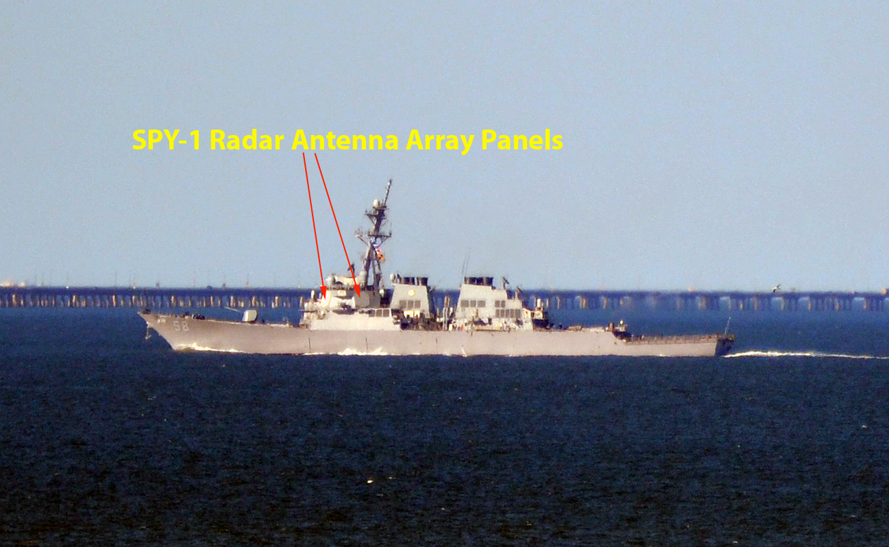
SPN-43 Shipborne Radar
SPY-1 Shipborne Air Surveillance Radar
Standard LTE Bands
UK Broadband
WRC 23 Agenda Item 1.2 IMT identification
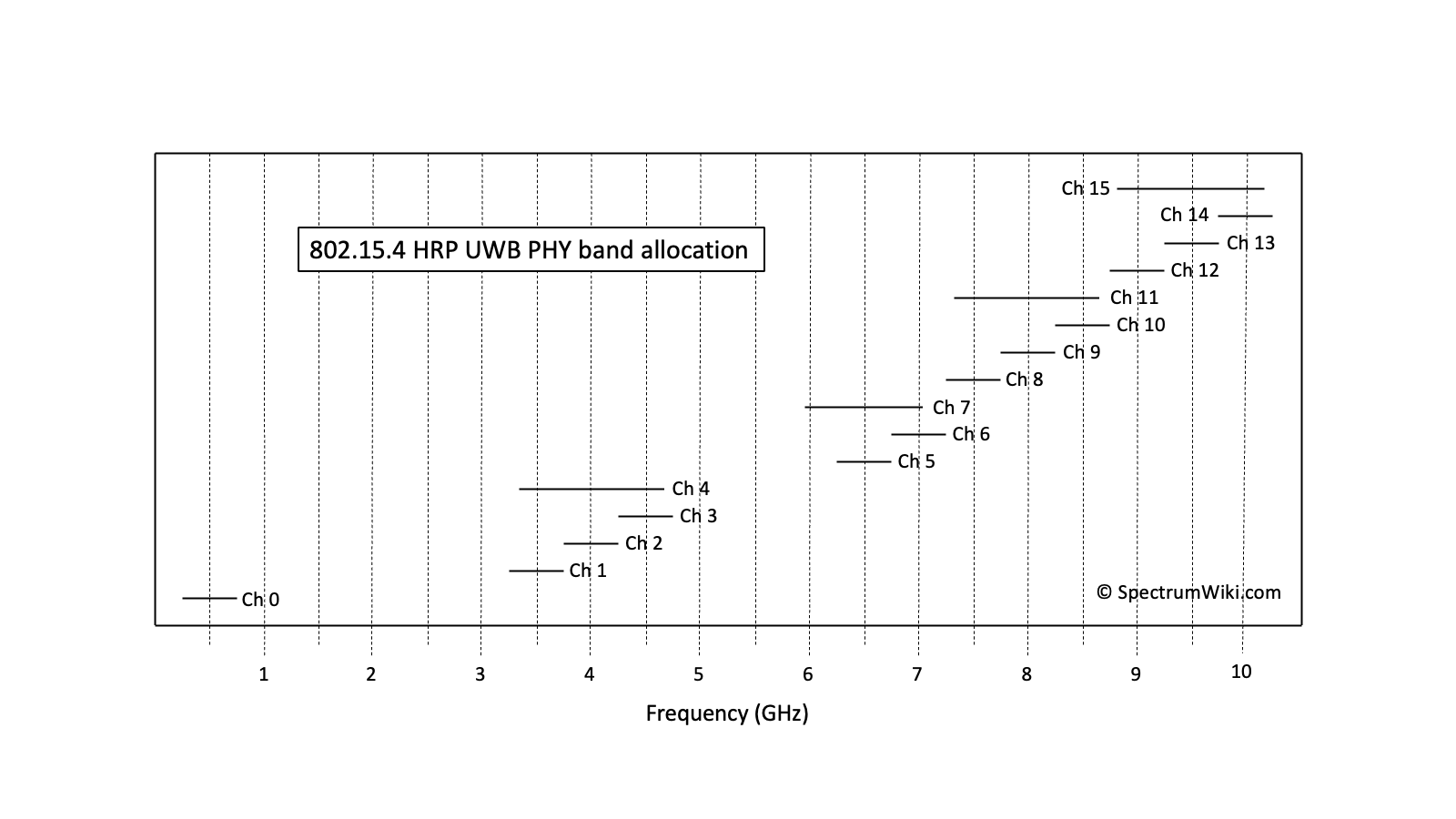
IEEE 802.15.4 HRP UWB
Through-wall Radar waiver
Actions to support FSS Earth stations in 3400-4200 MHz (WRC-15 Agenda Item 9.1.5)


Related Documents, Links, and Multimedia:
Band Plan (1)
Other (1)


Engineering Data

Lower Frequency Center Frequency Upper Frequency
Frequency 3.3 GHz 3.4 GHz 3.5 GHz
Wavelength 9.1 cm 8.8 cm 8.6 cm
Band designator(s) SHF; S-band (IEEE) SHF; S-band (IEEE) SHF; S-band (IEEE)
Isotropic collecting area 6.6 cm2 6.2 cm2 5.8 cm2
Free space loss (1 m) 42.8 dB 43.1 dB 43.1 dB
Free space loss (1 km) 102.8 dB 103.1 dB 103.1 dB
Free space loss (10 km) 122.8 dB 123.1 dB 123.1 dB
Free space loss (100 km) 142.8 dB 143.1 dB 143.1 dB
Free space loss (1000 km) 162.8 dB 163.1 dB 163.1 dB
Free space loss
(35,786 km = GEO orbit)
193.9 dB 194.2 dB 194.2 dB
Free space loss (378,370 km = Moon) 214.4 dB 214.6 dB 214.6 dB
Simple HTML Table